
Daisetsuzan National Park
Daisetsuzan National Park
(Area: 226,000 hectares; approximately 60 km from north to south and a maximum of 50 km from east to west)
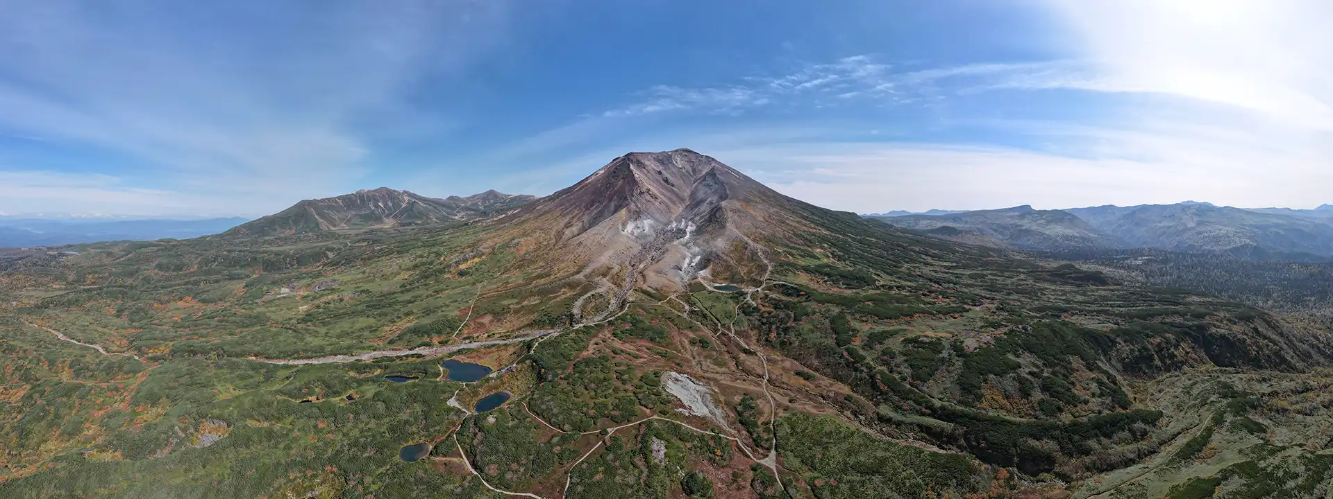
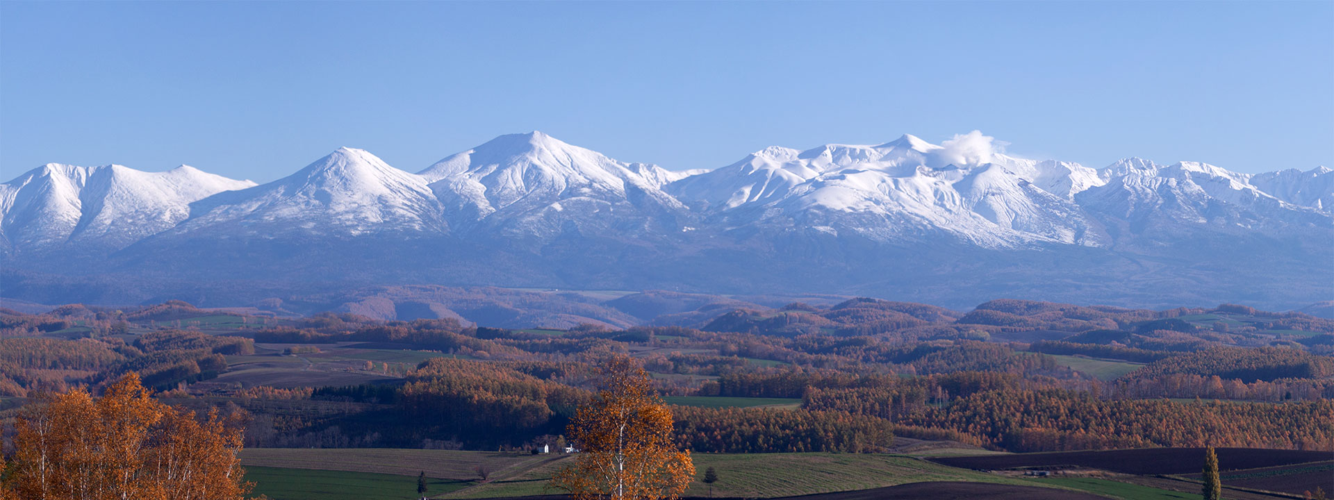
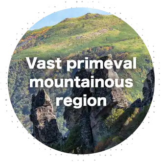
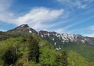
Daisetsuzan was designated as a national park on December 4, 1934, because it is home to a primeval mountainous environment that is more untouched than almost anywhere else in Japan. At the center of this majestic mountain range is the Daisetsuzan volcanic group, the highest of which is Mt. Asahidake. Hokkaido’s two longest rivers, the Ishikari River and Tokachi River, also start here.
In Japanese, “zan” is usually equivalent to “Mount” in English, but Daisetsuzan is a collective name for all of the mountains that form the central highlands of Hokkaido.
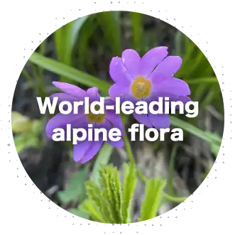
These mountains are comparatively small, standing only around 2,000 m high, but their northern location means they face severe weather conditions similar to their 3,000 m counterparts in Honshu. The mountain range attracts many climbers for its abundance of rare species including fauna that have existed since the Ice Age, such as northern pikas and Evermann’s parnassians, and brightly colored alpine flora including Aconitum yamazakii, which is endemic to the range. This beautiful scenery has earned it the Ainu name Kamuy mintar, which means “the playground of the gods”.
The national park is managed by the Ministry of the Environment, who are involved in initiatives based around the protection and use of this magnificent natural landscape.


Formation of Daisetsuzan
- 1,000,000 years ago
- It is believed that the volcanic activity that created the foundations of Daisetsuzan began around this time. There were more than ten colossal eruptions and many more smaller ones. One of the great eruptions, the Tokachi Pyroclastic Flow, caused a pyroclastic flow to spread across a vast area, creating the land that municipalities such as Asahikawa, Furano and Shintoku sit on today. Low-viscosity lava flowed far and wide, forming gentle slopes with an elevation of about 1,600 m (Takanegahara, Mount Chubetsu, Mount Niseikaushuppe, Mount Furano).
- 700,000 years ago
- 1,000,000 years ago
- 700,000 to 500,000 years ago
- The volcano at the center of the formation became active and a large eruption blew away the area near the summit. A caldera with a diameter of several kilometers was formed along with a somma. A dome-shaped peak rose along the outer wall of the somma, giving birth to new mountains (Mount Kurodake, Mount Hakuun, Mount Hokuchin, Mount Keigetsu, Mount Ryoun, Mount Oputateshike, Mount Nipesotsu).
- 150,000 years ago
- Volcanic activity started again in the center of an ancient caldera, and an eruption of high-viscosity lava formed new stratovolcanoes with an elevation close to 2,000 m (Mount Tomuraushi, Mount Tokachi).
- 30,000 years ago
- The Ohachidaira Central Volcano erupted violently, blowing off its top and forming the Ohachidaira Caldera.
The large eruption resulted in extensive pyroclastic flow and a huge glowing cloud. The pyroclastic flow swallowed up mountains in its wake, including Mount Kurodake, and filled the valley where the Ishikari River flowed. Sediment roughly 150 to 200 m thick cooled and solidified, creating columnar jointing.
The pyroclastic flow from this eruption also entered the Ishikari River and blocked it, creating the Old Taisetsu Lake (7 to 8 km wide).
- 20,000 to several thousand years ago
- The outer wall of Ohachidaira Caldera was worn down by erosion and water from the caldera lake flowed out, creating present-day Ohachidaira (Ohachidaira, Akaishi River).
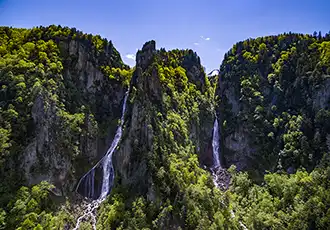
Volcanic activity started again near Ohachidaira Caldera. A stratovolcano was formed and lava flowed across a wide area including the Chubetsu River Basin (Mount Asahidake, Mount Hokkai, Ryusei-Ginga Falls).
- 600 years to present
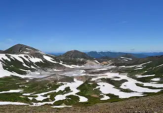
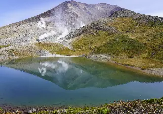
- There was a steam-blast eruption at the western side of the summit of Mount Asahidake, which was so big it changed the shape of Mount Asahidake and formed an explosion crater known as a “hell valley”. The crater from the volcanic eruption settled down and filled with water, forming a pond. Even today, it has many active vents that emit hot volcanic gases and vapors (Sugatami Pond).
Main mountains of Daisetsuzan
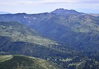
The vast alpine zone of Daisetsuzan is divided into four main groups of mountains.
North Daisetsu (Mount Niseikaushuppe, Mount Hirayama, Mount Murii), East Daisetsu (Ishikari Mountain Range, Lake Shikaribetsu), Tokachi Volcano Group (Mount Tokachi, Mount Furano, Mount Oputateshike) and Omote Daisetsu.
Omote Daisetsu makes up the main part of the national park. It includes Mount Asahidake and the rest of the Daisetsuzan Volcanic Group, and the vast mountainous region to the south. Omote Daisetsu mainly covers the area sandwiched between the Ishikari River and the upper reach of the Chubetsu River, including Numanotaira, Ginsendai, Mount Akadake, Kogen Onsen and Mount Tomuraushi.
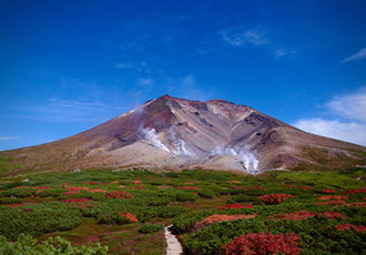
- Mount Asahidake
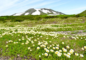
- Mount Asahidake is Daisetsuzan’s main peak with an elevation of 2,291 m. Located in the southwest part of Daisetsuzan, it is a stratovolcano made of andesitic lava that erupted in the alluvial age, and is the youngest mountain in the Daisetsuzan Volcanic Group. The west side of the summit has an explosion crater, known as a hell valley, with active fumaroles emitting gas and hot vapor. There is a ropeway that connects Asahidake Onsen to Sugatami Pond at an elevation of about 1,600 m, as well as a walking path. The walk around the Sugatami Pond is popular among hikers and tourists alike for its variety of alpine flora such as Geum pentapetalum. In winter, the mountain is a popular spot among skiers and snowboarders who come for the powder snow.
- Mount Kurodake
- Located in the northeast part of Daisetsuzan, Mount Kurodake has an elevation of 1,984 m. Its name means Black Mountain, and it is believed to have been named for its deep green color that goes all the way to the summit, a rare phenomenon in a volcanic mountain range like Daisetsuzan. A ropeway and a lift take you near the 1,500 m point, so it’s popular among beginners and families as a gateway for hiking in Daisetsuzan. Other popular activities are to stay overnight at the Kurodake Ishimuro Hut, southwest of Mount Kurodake’s summit, or to walk along rim of the Ohachidaira crater on the Ohachidaira-meguri trail. The slopes along the trail remain covered with snow until early July, and the ski trails that run under the lift are a popular spot for spring skiing as they can be enjoyed until early May.
Snow quality of Daisetsuzan
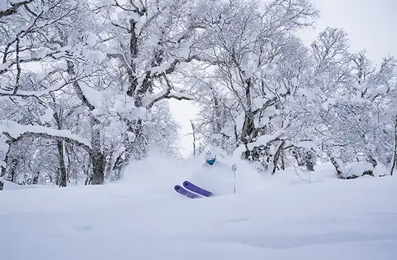
The temperature and humidity at Daisetsuzan create the perfect conditions for amazing powder snow. Another reason powder snow forms so easily here is because inland areas surrounded by mountains, like Asahikawa, have lower temperatures than areas near the sea. The Daisetsuzan region receives heavy snowfall due to seasonal winds from the Sea of Japan. The winds that bring snow to the Sea of Japan coast hit the Teshio Mountains where new snow clouds are formed, causing snow to fall with larger snow crystals than usual (7 mm to 1 cm).
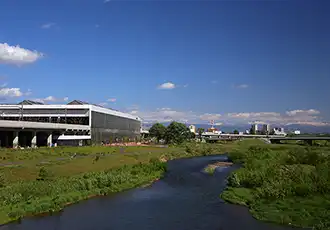
Kamikawa Basin
Located virtually in the center of Hokkaido, this basin has the Daisetsuzan Volcanic Group to the east, the Teshio and Yubari mountains to the west, the Nayoro Basin to the north, and the Furano Basin to the south. The Ishikari River and Chubetsu River, which start in Daisetsuzan, and the Biei River, which starts in Mount Tokachi, all merge at the Kamikawa Basin and flow towards the Ishikari Plain.
The inland climate means that the winters are cold and harsh, while the summers are hot enough for good rice farming. The area is characterized by abundant water; large, flat plains; and a landscape of mixed needleleaf and broadleaf forests and rice paddies.
- Ishikari River
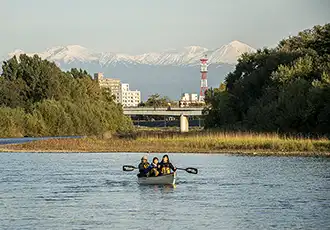
- The Ishikari River, the largest river in Hokkaido, starts in Mount Ishikari in Daisetsuzan, flows down the Sounkyo canyon to Kamikawa Town, and enters the Ishikari Plain in Asahikawa City, where it is joined by the Chubetsu River, Biei River, and other tributaries. It is known as i-sikar-pet, meaning “greatly meandering river”, in the Ainu language because it meandered and flooded the vast, peaty, low-lying marshlands time and time again. It is a Class A river with a basin covering an area of 14,330 km2 (the second largest in Japan) and a length of 268 km (the third longest in Japan). The river swells with the snowmelt from Daisetsuzan in spring. Its basin covers 46 municipalities, including Sapporo City and Asahikawa City, and is the social, economic and cultural center of Hokkaido.
- Chubetsu River
- Starting in Mount Chubetsu, this is a Class A river and a tributary of the Ishikari River. It flows for 59 km, passing through Asahikawa City, Biei Town and Higashikawa Town. It is known for its rapid currents, and it is believed that its name comes from the Ainu word ciw-pet, meaning “raging river”. It is also believed that this name was loosely translated into Japanese to mean “river where the sun rises”, which is where Asahikawa gets its name from. The upper middle basin is covered with rice paddy fields, while Asahikawa City is situated on the lower basin. The river’s abundant water supply is an essential part of people's daily lives: it supplies hydroelectric power generation and tap water, and serves as a pillar of economic activity.
Diverse alpine flora
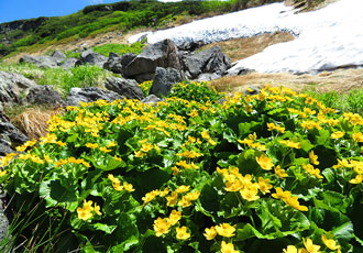
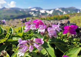
Various alpine flora grow across the vast alpine zone of Daisetsuzan due to its terrain and weather conditions.
Daisetsuzan’s alpine zone begins at an elevation of 1,700 to 1,800 meters, where more than 200 plant species grow, including many endemic species found only here, each adapting to their respective environments.
Permafrost*, reportedly only found in Daisetsuzan, at the summit of Mount Fuji, and on Tateyama in Japan’s Northern Alps, also greatly aids the growth of alpine flora in the summer, forming one of the largest alpine flora regions in the world and creating a vast, colorful landscape.
Survivors of the Ice Age
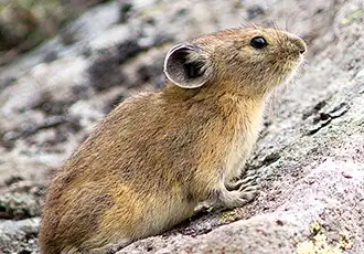
- Northern pika
- The northern pika migrated to Hokkaido from Siberia during the Ice Age when the two regions were joined by land. After the planet warmed, northern pika survived by living in suitably cold, high-altitude areas. They inhabit rocky slopes on high mountains, and make burrows in places such as underneath rocks where there’s a lot of vegetation. They are one of the best-known mammals that inhabit Daisetsuzan, and are very popular thanks to their cute appearance. Many hikers come to Daisetsuzan just to see the northern pika.
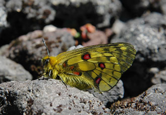
- Eversmann's parnassian
- Just like the northern pika, this butterfly crossed over into Hokkaido during the Ice Age.
The larvae feed on the leaves and flowers of dicentra, also known as the Queen of alpine plants.
In 1965, they were designated as a natural monument.
Earliest autumn leaves in Japan
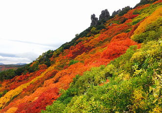
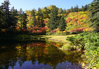
Autumn leaves begin in late August in the Daisetsuzan alpine zone and color the area for about a month and a half, starting from the summit and gradually spreading to the foot of the mountains. Small plants such as Arctous alpina and Aleutian avens turn bright red, and as you enter the forest zone, trees such as Japanese Rowan, Erman's Birch, Japanese Maple and katsura turn red, orange and yellow, creating a breathtakingly vivid contrast with the green of the coniferous trees. One of the most popular hiking trails to enjoy this stunning foliage is the Daisetsu Kogen Numa-meguri Loop Hike, which starts at an elevation of 1,260 m and takes you through the depths of Daisetsuzan National Park. The area is home to a mixed forest of broadleaf and coniferous trees and dotted with ponds and marshes of all sizes. (Note: private cars are restricted during fall.) Primeval forests of coniferous trees such as Sakhalin fir and Ezo spruce used to stand here, but they were destroyed by Typhoon Marie in 1954. After that, pioneer trees such as Erman's birch grew along with new coniferous trees, creating Daisetsuzan’s forest as we know it today.
- Reference materials
- Daisetsuzan National Park Volunteer Liaison Committee
Hokkaido Regional Development Bureau, Ministry of Land, Infrastructure, Transport and Tourism